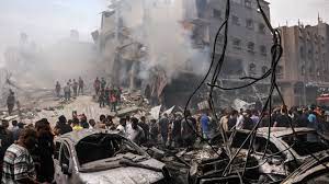
Satellite images commissioned by the BBC expose extensive destruction across Gaza, indicating potential damage to nearly 98,000 buildings.

These images, captured prior to a recent seven-day suspension of hostilities, depict the aftermath of Israeli airstrikes and ground fighting. Drone footage and verified videos further illustrate the devastation, with buildings and entire neighborhoods reduced to rubble. While the northern part of Gaza has been the primary focus of the Israeli offensive, significant damage is evident throughout the entire strip. Israel asserts that northern Gaza, including Gaza City, served as a “center of gravity for Hamas,” the group responsible for the October 7 attacks. The Israeli military claims success in targeting Hamas commanders and fighters, accusing the group of using civilian areas for cover. Satellite data analysis conducted by Corey Scher of City University of New York Graduate Center and Jamon Van Den Hoek of Oregon State University indicates potential damage to almost 98,000 buildings across Gaza, predominantly in the north. The analysis is based on comparisons of two images, revealing changes in building height or structure indicative of damage. Cities like Beit Lahia and Beit Hanoun in the north and north-east of Gaza have faced substantial destruction, with bulldozers clearing paths through the rubble and the Israeli military establishing defensive positions in surrounding fields.